Central Valley Flood Protection Board
The Central Valley Flood Protection Board (Board) establishes, maintains, and enforces standards for the construction, maintenance, and operation of the flood control system to protect life, property, and habitat in California’s Central Valley. The Board coordinates State entities, local flood risk control agencies and the federal government to minimize damages from floods in California’s Central Valley and is the non-federal sponsor for federal flood control projects in the State Plan of Flood Control. The Board serves as a public forum for flood risk reduction policy in the Central Valley and is responsible for adopting updates to the Central Valley Flood Protection Plan every five years.
Active Meeting Notices
To stay up-to-date on all of our meeting notices, please subscribe to our CVFPB Meetings Bulletin.
PUBLIC HOURS AND MEETING SCHEDULE
In accordance with the Governor’s order, the Board will continue to host hybrid meetings and workshops. Locations and access information for future meetings will be posted on our homepage and updated as needed.
For public drop off of physical documents, including applications and fees, we can be contacted by phone or email as noted below to schedule a drop off.
-
With our new hybrid teleworking environment, most staff are only at our office location on Tuesdays each week. Administrative staff are available at the front desk Tuesdays and Thursdays from 8:30 am – 3:00 pm. Appointments are required to meet with staff or receive in-person assistance at the front desk. If you are currently working with a staff member on an item, please continue to contact that staff member. If you need general information, please contact the general mailbox at Questions@CVFlood.ca.gov.
-
We will be prioritizing permits based upon health and safety factors, including the availability of staff and partners, and application processing times may be extended during this period. Please bear with us as we work through this new system.
-
Past recordings of Board meetings and workshops can be found on the CVFPB YouTube Channel
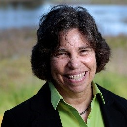
Jane Dolan
Board President
NEWS & HIGHLIGHTS
CVFPB Staff Activated to Protect LA County Watersheds from Post Fire Pollutants
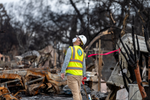 Board staff, Zachary Ramsey and Joshua Kaup, were activated by the Department of Water Resources’ (DWR) Department Operations Center on January 28, 2025 to help provide watershed protection measures after the devastating Palisades and Eaton fires in the Los Angeles region. They assessed sites and directed teams of California Conservation Corps workers installing Best Management Practices to prevent contaminants in surface water from reaching local waterways. Together, their efforts helped protect watersheds surrounding 13,745 parcels from post-fire contaminant runoff. This was a monumental undertaking, and their work was a big part of its success. This was a joint collaborative effort executed by DWR, the Central Valley Flood Protection Board, and Caltrans.
Image taken from DWR’s Public Affairs Office
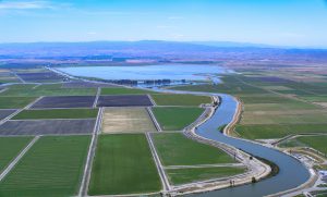
DWR: State Water Project allocation increased to 35%
 From Maven’s Notebook,
From the Department of Water Resources:
Today, the Department of Water Resources (DWR) announced that recent storms have allowed for another increase to the State Water Project (SWP) allocation forecast for 2025. The allocation has increased to 35 percent of requested water supplies, up from 20 percent in January based on increases in precipitation, snowpack, and reservoir storage. The SWP provides water to 29 public water agencies that serve 27 million Californians and 750,000 acres of farmland across the state. The latest allocation forecast takes into account precipitation and snowpack conditions up to February 10, prior to a cold storm that brought welcome snow to the Sierra. That snowpack will be included in future water supply calculations along with any forecasted dry conditions ahead. (more)
DWR issues an official notification of validation action for Delta Conveyance Program bond financing
From Maven’s Notebook,
From the Department of Water Resources,
The Department of Water Resources (DWR) has issued a Notice of Validation Action for Delta Conveyance Program bond financing. This provides an official notification of the “validation action” DWR filed with the Sacramento County Superior Court in January regarding DWR’s authority to, among other things, issue revenue bonds to finance the planning, design, construction and other capital costs of Delta conveyance facilities, such as the Delta Conveyance Project DWR approved in December 2023. (more)
 Visit the State of California


Quick Links
- ABOUT US
- ACCESS TO PUBLIC RECORDS
- TRIBAL CONSULTATION POLICY
-
OTHER RELATED LINKS
U.S. Army Corps of Engineers (USACE)
USACE Section 408
USACE Section 404
The California Natural Resources Agency
Department of Water Resources (DWR)
Delta Stewardship Council
Regional Flood Management Coordinating Committee
U.S. Bureau of Reclamation
U.S Fish & Wildlife Service
National Marine Fisheries Service
California Emergency Management Agency
California Department of Fish & Wildlife
National Committee on Levee Safety (USACE) - CAREER OPPORTUNITIES
- CONTACT US
- California Government Code 65007 (SB 5, 2008)
- Central Valley Flood Protection Plan
New Board Member