
From USACE Sacramento District – The U.S. Army Corps of Engineers is the federal government’s largest water resources development and management agency. Through the Floodplain Management Services (FPMS) program, the Corps provides information on flood hazards to local interests, state agencies, and other federal agencies to guide development of the floodplains of the rivers of the United States. The FPMS program addresses the needs of people who live and work in floodplains to know about flood hazards, and the actions they can take to reduce property damage and prevent the loss of life caused by flooding. The program’s objective is to foster public understanding of the options for dealing with flood hazards and to promote prudent use and management of the nation’s floodplains. The FPMS program provides a full range of technical services and planning guidance that is needed to support effective floodplain management. (more)
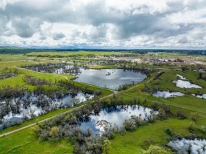
From mavensnotebook – DWR report – Recent cycles of extreme drought and flood, and the passage of the Sustainable Groundwater Management Act (SGMA) provide an enhanced opportunity to strengthen the nexus between flood and groundwater management. The need for using floodwaters for managed aquifer recharge, also known as Flood-MAR , is urgent and must be considered as a crucial part of California’s portfolio of sustainable and resilient water resource management strategies. This approach can be utilized on floodplains and flood bypasses to reduce flood risk and increase groundwater recharge potential, as well as provide ecosystem benefits through restored and reconnected floodplains. (more)
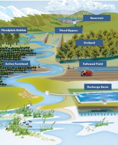
From CA Dept. of Water Resources/Flood-MAR – Recent cycles of extreme drought and flood, and the passage of the Sustainable Groundwater Management Act (SGMA) provide an enhanced opportunity to strengthen the nexus between flood and groundwater management. The need for using floodwaters for managed aquifer recharge, also known as Flood-MAR , is urgent and must be considered as a crucial part of California’s portfolio of sustainable and resilient water resource management strategies. This approach can be utilized on floodplains and flood bypasses to reduce flood risk and increase groundwater recharge potential, as well as provide ecosystem benefits through restored and reconnected floodplains. (more)
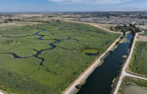
From The Mercury News – Scientists estimate that more than 350,000 acres of tule marsh once blanketed the area from Sacramento to Stockton, yet only 2% to 5% of those are left. European settlers moved here in the Gold Rush days and many hired Chinese immigrants to divert the waters and build levees for farming. Because many of those “farming islands” have now sunk some 20 to 25 feet below sea level – too low for plants when the tides come in – there are fewer opportunities now to build tidal marshes, according to John Cain of River Partners, a nonprofit that works on large-scale habitat restoration projects. Considered the project’s visionary, Cain got involved in promoting the wetland project in the late 1990s while working for the Natural Heritage Institute. Knowing Dutch Slough land was at the mouth of Marsh Creek, filled with mineral soils and clay, the restoration ecologist understood it had not sunk as low as some other areas and could be transformed into a tidal marsh. (more)
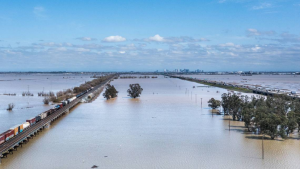
From the Sierra Sun Times – The Central Valley is extremely vulnerable to severe flooding, and levees are the first line of defense. According to a recent annual risk assessment, 92% of properties and 97% of commercial buildings in the City of Stockton are at risk during a flood. The Safeguarding Our Levees Act ensures high-risk communities are protected and levees are quickly fixed by streamlining the Army Corps’ levee rehabilitation program. On Tuesday, Representatives Josh Harder (CA-9) and Clay Higgins (LA-3) introduced bipartisan legislation to protect communities from severe flooding and get damaged levees in flood-prone areas fixed as quickly as possible. The Safeguarding Our Levees Act would cut through the red tape that slows down the Army Corps of Engineers’ efforts to repair levees – the bill also reduces the financial burden of levee improvements for local communities. After heavy rainfall like Northern California saw earlier this year, communities rely on the Army Corps to repair levees quickly before another flood. Right now, red tape can slow the Army Corps’ work to rehabilitate levees by months or even years, leaving communities unprotected for the next flood event. This legislation is endorsed by the San Joaquin Area Flood Control Agency (SJAFCA). (more)

From mavensnotebook.com – This year marked the launch of an OpenET-based website for reporting water use in the Delta, and 70 percent of growers there have already adopted it. OpenET was developed to help people manage water sustainably. The platform gets data in part from Landsat satellites, which are managed by the National Aeronautics and Space Administration and the U.S. Geological Survey. Other inputs include surface weather such as air temperature, humidity, wind speed, and precipitation. Each pixel in Landsat satellite images is 30-meters across, which is about the size of a baseball infield, or—more important for resource management—an average U.S. crop field. Illustration by NASA. Landsat satellites have thermal sensors that detect heat on the Earth’s surface. In agricultural fields, the surface temperature reflects how much water is used by crops. This is due to a process called evaporative cooling, which uses heat from sunlight to evaporate water from, in this case, the leaves and tender stems of plants. In areas where plants use more water, the surface temperature is lower. The same process helps cool people down when they sweat. Measuring crop water use is more important than ever. “With drought and climate change, we’re facing the ever increasing challenge of doing more with less and less water,” says Robyn Grimm, an Environmental Defense Fund hydrologist who is interim director of OpenET. Agriculture accounts for about 80 percent of the water used in California as well as in other western states. (more)
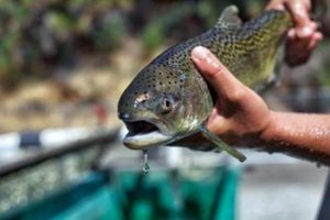
From mavensnotebook.com – Two years ago, California’s winter-run chinook were dealt a devastating blow. These endangered salmon were already struggling to survive, with as few as one thousand adults returning from the ocean to spawn in recent years. Then, in 2021, a sizzling summer on top of a severe drought killed three quarters of the eggs the fish laid in the Sacramento River near Redding, their last remaining spawning grounds. Now, a new plan to help protect winter-run chinook eggs is in the works. (more)
From The Sacramento BEE– Housing for homeless residents living with mental illness. Defenses against wildfires, droughts and floods. New and renovated school campuses. Treatment centers for fentanyl users. California voters can expect to be asked to approve billions of dollars in bonds in 2024 to help the state address a myriad of pressing issues. Lawmakers in Sacramento have proposed about a dozen bond measures that they want on ballots in March or November of next year. They include a $4.7 billion ask for up to 10,000 new behavioral health beds, $15 billion to make the state more resilient to climate change, $14 billion to modernize school facilities, and $10 billion for affordable housing construction. (more)

From Sacramento News & Review – Across California, nearly 14,000 miles of levees stand between flood waters and residents, and anxious emergency managers plan for their failure, because levees were designed and built to reclaim floodplains for agriculture. It is only with population growth that levees have taken on a role for which they weren’t designed. California has a long history of federal partnership in levee construction for reclamation. The US Army Corps of Engineers (USACE) maintains oversight, while most are managed locally. Annual federal allocations provide the bulk of funds for repairs, but the state and municipalities typically fund 25%. (more)
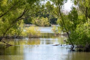
From PPIC – The San Joaquin Valley is one of the most productive agricultural regions in the world, and much of its success comes from the waters of the San Joaquin River. Historically, the big challenge in managing this river was how to harness its waters for irrigation while also reducing the impacts of floods. Today, another big challenge has been added to the mix: how to undo some of the damage done to the environment and to reconnect the river to its many communities. The San Joaquin River and its tributaries—including the Merced, Tuolumne, and Stanislaus rivers—drain the west slope of the Sierra Nevada, flowing north into the Sacramento–San Joaquin Delta. (more)