 Several days of torrential rains in Northern California and high flows along the Sacramento and San Joaquin Rivers are testing the health of the Central Valley’s flood control system, which features an extensive network of levees. The state’s levee network is in generally good health, and both forecasters and flood experts remain optimistic.
Flows on the San Joaquin River at Vernalis are forecast to continue rising for the next few days, cresting approximately 0.6 feet below Monitor Stage. Astronomical high tides peaked on January 12th, but are expected to remain relatively high over the next few days.
Several forecast points along the North Coast, Sacramento, and San Joaquin river basins have exceeded monitor or flood stage and most are currently receding. Mokelumne River at Benson’s Ferry peaked at just above the flood stage on January 12th and is forecast to recede below flood stage by early Friday afternoon.
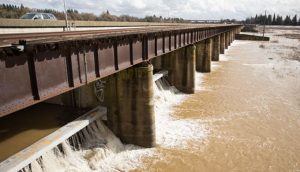
Department of Water Resources (DWR) staff opened a total of 35 of the 48 gates on the Sacramento Weir to maintain stages in the Sacramento River at I Street below 30 feet. Sacramento Maintenance Yard is monitoring stages at the weir to ensure operational criteria are maintained. Fremont, Tisdale, Colusa, and Moulton weirs are flowing and are expected to flow for approximately one week.
Peak water levels on many rivers in the North Coast, Russian, Napa and Sacramento basins have passed and are receding. Clear weather is expected Friday afternoon, January 13th through the weekend. The next chance of significant precipitation is the middle of next week.
Picture of open gates at the Sacramento Weir