 From Engineering with Nature, the California Swing,
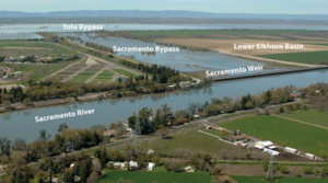
Todd Bridges (USACE’s Engineering with Nature Program) -The Sacramento is a “beast” of a river. It runs 400 miles from Mount Shasta to the delta where it meets up with its southern sister at the Sacramento-San Joaquin River Delta, as both rivers join with the San Francisco Estuary and Bay. The Sacramento River drains a watershed encompassing 26,000 square miles. Before dams and impoundments were constructed in the watershed, peak discharges during the wet season are estimated to have reached 650,000 cubic feet per second (cfs), which is second only to the Columbia River on the Pacific Coast of the United States, and is comparable to annual average discharges on country’s largest river, the Mississippi. Consistent with California’s climate, the Sacramento’s flow during dry periods can drop below 1,000 cfs. But it’s during periods of high flow when the Sacramento River has left its marks on California’s landscape and history. In 1917, Congress authorized the Sacramento Flood Control System that provided federal involvement and support, through the US Army Corps of Engineers, to implement the plan envisioned by Hall, which combined strengthened levees with the plan’s main feature and innovation: the system of weirs and bypasses. The central element and largest feature of the system is the Yolo Bypass. (more – https://ewn.erdc.dren.mil/?p=6738)
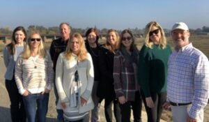
Picture (left) of the multi-agency crew visiting the Sacramento Weir and Bypass (from left to right): Corrie Stetzel (Senior Planner, USACE Sacramento District), Melanie Saucier (Principal Planner, Sacramento Area Flood Control Agency), Gary Bardini (Director of Planning, Sacramento Area Flood Control Agency), Melissa Weymiller (Tribal Partnership Program Manager, USACE Sacramento District), Alicia Kirchner (Chief of Planning, USACE Sacramento District), Laura Hollender (Policy Advisor, CA Department of Water Resources), Sara Schultz (Plan Formulation Specialist, USACE South Pacific Division), Ruth Darling (Program Manager, Central Valley Flood Protection Board), and Todd Bridges.
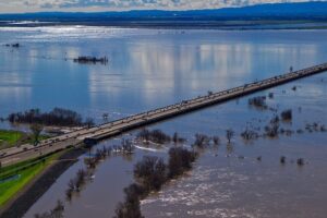
Picture (right) is the Yolo Bypass inundated during high river flows in February 2017 (Source: USFWS Photo/Steve Martarano).