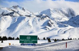
 From AOL News – Flying thousands of feet above the Sierra Nevada in a plane equipped with specialized imaging devices, Elizabeth Carey has been scanning the mountains with lasers to precisely map the snow. The snow blanketing the Sierra lies so deep that the mountain range looks surprisingly swollen and “puffy,” said Carey, who leads the flights as part of a state-funded program. “The amount of water that we have in the snowpack this year is just mind-blowing,” she said. “It’s just been extraordinary.” By mapping the snowpack with laser pulses and spectrometers, Carey and her colleagues are able to provide a detailed picture of one of the biggest snow accumulations ever recorded in the state. The flights are also collecting data to estimate when and how fast the snow will melt, helping California officials prepare for the runoff, manage water releases from dams, and assess which areas are most at risk of flooding. (more)
-
- Translation Notice