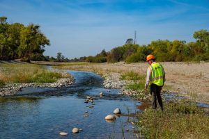
 From CBS News, Channel 13 – A habitat restoration project in the lower Yuba River is complete. The project not only helps the local fish population but also those who live along the river’s banks.
“The Hallwood Fish Habitat Project” restored the natural flow of the Yuba River after decades of collecting debris from hydraulic mining during the Gold Rush. Aaron Zettler-Mann, executive director of the South Yuba River Citizens League, said he’s proud of the project and the flood plain it’s created. “Prior to this project, really, the Yuba River was characterized by training walls, so massive piles roughly 80 feet tall of just aggregate,” Zettler-Mann said. Willie Whittlesey, general manager of the Yuba Water Agency, said these training walls within the Yuba Goldfields are where hundreds of millions of cubic yards of hydraulic mining sediment were deposited in the lower Yuba River through the early 1900s. (more)
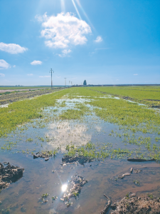 From AgAlert – The historically wet winter early this year motivated greater adoption of a water management strategy known as flood-managed aquifer recharge, or flood-MAR, in which excess flood flows are diverted onto farmland to boost depleted groundwater aquifers. “We knew from the previous year, even in intense drought years, we have opportunities with these big storm events and need to do everything we can,” said California Department of Water Resources Director Karla Nemeth, addressing water managers, farmers, government officials and others, as part of the Flood-MAR Forum in Sacramento last week. “Our ability to respond to those kinds of intense rain events is becoming increasingly important.”
Pointing to atmospheric rivers that hit the state in January, Nemeth highlighted the executive order by Gov. Gavin Newsom that enabled farmers to divert water onto farmland for groundwater recharge, which also helped mitigate flooding impacts. Taking advantage of wet conditions is important for the state, especially as local groundwater sustainability agencies, or GSAs, have until 2040 and 2042 to implement plans and projects to bring groundwater basins into balance, as required by the Sustainable Groundwater Management Act, or SGMA. (more)
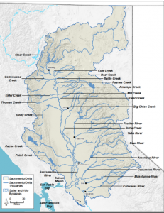
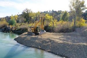 News release from the Sacramento River Settlement Contractors on mavensnotebook.com – More than 21,000 tons of gravel is being placed into the Sacramento River to provide spawning habitat for salmon and trout in the upper reaches of the river and its tributaries. The spawning habitat has been reduced over time due to water flows pushing the gravel downstream. Spanning approximately 200 feet by 80 feet, the new gravel aims to replenish supply in an important historic spawning location near Salt Creek – about a mile south of the Keswick Dam. “We are addressing a need in one of the salmon’s key life stages with the hope that more fish will spawn in the colder waters of Sacramento River,” said Roger Cornwell, President of Reclamation District 108. “With less debris entering the river and creeks naturally, we know it is important to lend a hand to our endangered species.” (more)
 From FISHBIO – Wetlands are vitally important ecosystems that serve as critical habitat for numerous species of flora and fauna and provide incredibly valuable ecosystem services in the form of carbon sequestration, flood risk reduction, nutrient cycling, and water filtration. Despite their importance, these habitats have been lost at a dramatic rate. Humans are experts at wetland draining and reclamation, so much so that an estimated 60 acres (an area equivalent to more than 45 football fields) of wetlands were lost every hour in the lower 48 states between the 1780s and 1980s. Though this rate has slowed in recent decades, it certainly hasn’t stopped. Globally, about 1,544 square miles of tidal wetlands were lost in just the last 20 years. However, as the understanding of the value of healthy wetlands has improved, there have been growing efforts to restore these ecosystems. This is particularly true in the Central Valley of California, which has only about 10% of its historic wetlands remaining. To rebuild these critical habitats, an inter-agency agreement known as the Fish Restoration Program (FRP) was made between the California Department of Fish and Wildlife and the California Department of Water Resources in 2010. Since its inception, the FRP has made significant strides toward restoring wetlands, and a workshop was hosted by the State Water Contractors on November 1 to review current progress and discuss work that remains to be done. (more)
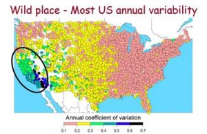 From mavensnotebook.com– Capturing water from wet periods for use in drier seasons or years has been central to California’s water management since the early 1900s. Reservoirs and aquifers are routinely used for this purpose by many agencies and regions. How much more water can be saved in wetter times for later use? How much would this cost? What are the potential environmental costs (and benefits) of storing additional water? Dr. Jay Lund, Vice Director of the Center for Watershed Sciences and an engineering professor at UC Davis, dove into those questions in the presentation for Sacramento State’s Office of Water Programs webinar series. (more)
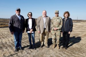 California Department of Water Resources, 10/23/2023 – Extreme weather events in California in 2023 highlight the need for more awareness of flood risks in California and now is the time for all Californians to prepare for possible flooding. That was the message from state and federal agencies gathered today to show how they are joining forces to protect communities from another potential wet winter. (more)
 Nonstructural Flood Risk Mitigation Workshops and Paradise Cut Tour – November 1 – 2, 2023
Join us for practical workshops and a tour focused on innovative flood risk reduction solutions. Our workshop for residents provides strategies and resources to safeguard your neighborhood. The workshop for policymakers offers insights into effective flood risk management. Also, take a guided tour of Paradise Cut to see the proposed project area up close and hear descriptions from experts who are working to implement the project. Don’t miss this opportunity to learn how this project can reduce flood risk in your community!
For more information:
https://www.google.com/search?q=dEpartment+of+water+resources+logo&rlz=1C1GCEA_enUS1029US1029&oq=dEpartment+of+water+resources+logo&gs_lcrp=EgZjaHJvbWUyBggAEEUYOTIICAEQABgWGB4yCAgCEAAYFhgeMggIAxAAGBYYHjIICAQQABgWGB7SAQg3MzE4ajBqN6gCALACAA&sourceid=chrome&ie=UTF-8#vhid=j4DVTQ6xVq0D0M&vssid=l
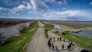
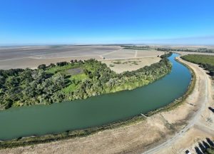 From CA Dept of Water Resources – As climate extremes continue to challenge water management, the California Department of Water Resources (DWR) is working with partners across the state to implement floodplain restoration projects that provide flood protection to communities and benefits for endangered species and natural habitat. With DWR’s assistance, River Partners and American Rivers will begin work on the restoration of over 1,000 acres of historical floodplain on the Sacramento River that will provide flood protection, enhance and expand critical habitat for fish and wildlife, and increase climate resilience in rural communities in Yolo and Sacramento counties. (more)
 From Cal Matters – California’s water warriors have a new arena for their perpetual conflict over the allocation of the state’s ever-evolving supply – a nearly 6,000-word proposal from the state Water Resources Control Board.
The draft essentially calls for sharp reductions in diversions from the Sacramento River and its tributaries to allow more water to flow through the environmentally troubled Sacramento-San Joaquin Delta. “It is a consequential effort,” Eric Oppenheimer, chief deputy director of the board, said during a media briefing on what is technically an update of the agency’s management plan for the Delta and San Francisco Bay. “It reflects years of scientific analysis that we’ve undertaken and years of public input.”
The board had previously issued a similar policy paper for the San Joaquin River and its tributaries. The two rivers merge to form the Delta, a vast maze of islands and channels that is the West Coast’s largest estuary. In addition to upstream diversions to irrigate fields and orchards and serve municipal users, federal and state projects pump water from the Delta’s southern edge into aqueducts for transfer to San Joaquin Valley farms and homes as far south as San Diego. The reduction of natural flows through the Delta have, scientists say, increased its salinity and otherwise made it unable to adequately support salmon and other wildlife. (more)
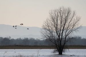
 From CalTrout – “As climate change exacerbates drought, it can often feel like there is not enough water to go around to protect the interests of both humans and wildlife. However, CalTrout takes a unique role in the conservation space to balance those interests and bring about benefits for both farmers and fish. How? In the Sacramento Valley, we work with a coalition of partners to reactivate floodplains. A floodplain is a low-laying area of ground adjacent to a river, subject to routine (you guessed it!) flooding. (more)