Central Valley Flood Protection Board’s Jurisdictional Area – Best Available Maps
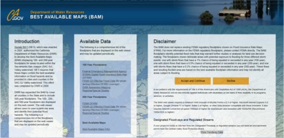
The link below will load a web based viewer that will assist you in determining if the proposed work may be located within the jurisdictional area of the CVFPB. The home page of the Best Available Maps (BAM) viewer provides two (2) options; 1) Clicking on the “Accept and Continue” button or the 2) “View Floodway Data” button.
- Clicking on the “Accept and Continue” button will take you to a page that provides maps for the 100, 200, and 500-year event floodplains. The floodplains produced by the USACE Comprehensive Study are for the Sacramento-San Joaquin watersheds. The 100 and 500-year FEMA maps are for the entire State. These maps are provided by the California Department of Water Resources for informational purposes and should not be used to determine if you need to submit an encroachment permit application to the CVFPB;
- Clicking on the gray “View Floodway Data” button located in the lower right-hand corner of the BAM home page will direct you to a page that provides layers for CVFPB Regulated Streams and Designated Floodways (DF’s) that have been adopted by the CVFPB. CVFPB adopted DF’s should not be compared to FEMA floodplains as they are not the same. Any proposed projects that are located within a DF or within 30-feet from the bank of a Regulated Stream will require a CVFPB Permit. Please contact CVFPB staff for all other proposed work that may be within 300-feet of a DF or a Regulated Stream as an encroachment permit may be required if it is determined that the project could have negative flood control impacts.
BAM Viewer http://gis.bam.water.ca.gov/BAM