
Weirs on the Sacramento River: 100 Years of Flood Control
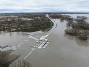
From CA Dept. of Water Resources – Set into the banks of the Sacramento River as it winds its way south from its Mount Shasta headwaters are six large concrete structures which, despite their size, go largely unnoticed until the rains come and the river rises, threatening floods. Then they get to work, channeling the deluge into bypasses and basins, and away from the levees and bridges of Sacramento and other downstream communities. These unobtrusive structures, called weirs, are distributed along a 95-mile stretch of the river from Butte City to North Sacramento, acting as silent sentinels protecting millions of Californians from flooding. “This system of weirs and bypasses is the backbone of the Sacramento River Flood Control Project,” said Manager of DWR’s Division of Flood Management Jeremy Arrich. “When these weirs are flowing, they’re taking pressure off the main stem levees and moving that water into the bypass system to flow safely downstream.” (more)