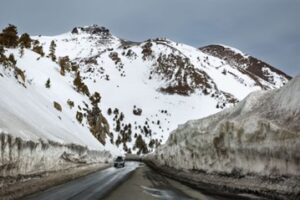
 From Stanford News – Billions of tons of snow piled atop the Sierra Nevada Mountains can cause parts of the Central Valley, just west of the range, to sink – muddling groundwater assessments that take sinking as a sign of depleted aquifers. A recent Stanford University study is now offering a way to account for this heavy mountain snowpack and more accurately gauge groundwater levels. Analyzing satellite-based measures of surface changes over time has emerged as a promising method for monitoring groundwater in places such as the agriculturally rich Central Valley, where farmers rely heavily on groundwater to irrigate crops in dry years. But the method requires a clear understanding of the true mechanisms behind any observed elevation changes. The new study, published April 28 in Geophysical Review Letters, shows how heaped-up snow and ice in the Sierra during California’s wet season depresses the valley floor, accounting for the majority of the detected elevation change in 60% of the valley. As tens or even hundreds of feet of snowfall pile up in the Sierra, as occurred in historic fashion this past winter, it causes the ground in the valley below to sink by anywhere from a tenth of an inch to an inch. (more)
-
- Translation Notice