
DWR Relaunches Water Management Boundary Tool
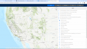
From California Department of Water Resources (DWR) – DWR’s Water Management Planning Tool has been relaunched as the Water Management Boundary Tool. It is an interactive map that allows users to overlay geographic information system (GIS) layers onto a California map and illustrate entities involved in water management in a given area. The tool can assist local agencies with their responsibilities related to the California Water Plan, integrated regional water management, and the Sustainable Groundwater Management Act. (more)