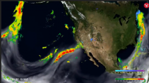
From The Independent tv – Scientists have developed the world’s first real-time map showing the flow of atmospheric rivers in the sky, which transport intense moisture and drive extreme rainfall, an advance that may lead to better flood predictions. When these atmospheric rivers laden with moisture hit the skies over land they may lead to extreme weather events such as cyclones or typhoons and flooding. But previous models to view these rivers overestimated the frequency of rain they produced while underestimating the rain’s intensity. Now the new model can automatically detect these sky rivers using satellite observations, and provide a much more accurate picture of impending extreme weather events around the world, scientists say. (more)